Context: the arbitral award at (nearly) ten years
An Arbitral Tribunal constituted in The Hague in accordance with Annex VII of the UN Convention on the Law of the Sea (UNCLOS) issued its landmark ruling on 12 July 2016, finding that China’s nine-dash-line claims had no legal basis and that Beijing had unlawfully interfered with Filipino fishing at Scarborough Shoal. As that ruling approaches its tenth anniversary in July 2026, the practical situation on the water tells a different story: China has maintained a continuous presence in the shoal since the 2012 standoff, and it expanded that presence in 2025 by declaring the feature a national nature reserve. The Philippines, for its part, has refused to concede the legal high ground, continuing to challenge China’s presence and to assert its sovereignty over the shoal, and its rights under UNCLOS as confirmed by the 2016 Arbitral Award.
Scarborough Shoal: a layered area-denial posture
China continued to reinforce its claims over Scarborough Shoal during the quarter through a layered patrol strategy that strengthened its area-denial posture, particularly after Filipino fishing vessels resumed operations within the shoal’s 12-nautical-mile territorial sea in February. Beginning in March, six to eight Chinese maritime militia vessels maintained a persistent presence inside the lagoon, returning after their departure in mid-2025.
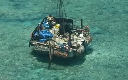
The quarter’s most concerning development came in late May, when Philippine authorities discovered a “floating structure” inside the shoal’s lagoon. Officials said the platform could be supporting unauthorized marine scientific research activities by China. In response, the Department of Foreign Affairs lodged a diplomatic protest against Beijing.
The discovery also raised concerns about the possibility of a more permanent Chinese presence at the disputed feature. Former Senior Associate Justice Antonio Carpio warned that the structure could represent a “precursor” to occupation in violation of the 2002 Declaration on the Conduct of Parties in the South China Sea. Drawing parallels with China’s earlier activities at Mischief (Panganiban) Reef in 1995, Carpio argued that the establishment of semi-permanent facilities would constitute the initial stages of occupation. “If they put up a platform there, that’s occupation,” he said.
Satellite imagery analyzed by commercial provider Vantor (formerly Maxar Technologies) and reported by Reuters further highlighted Beijing’s efforts to tighten control over access to the shoal. The imagery showed that China installed a floating barrier across the lagoon’s southeastern entrance between 10 and 11 April. According to Philippine Coast Guard spokesperson Rear Admiral Jay Tarriela, the barrier measured approximately 352 meters in length and was accompanied by four Chinese fishing vessels and a probable coast guard or naval patrol ship positioned outside the lagoon entrance. The barrier is the latest in a recurring pattern; a similar obstruction installed in September 2023 was cut and removed by Philippine divers on Manila’s orders. Its reappearance came as the Philippines was again escorting fishermen with coast guard and fisheries vessels, and it signals Beijing’s continuing intent to restrict access. Analysts have warned that the steady accretion of control measures by the Chinese keeps Scarborough among the most plausible flashpoints for armed confrontation in the region.
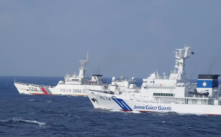
China Coast Guard activity nearer the Philippine coastline
China Coast Guard (CCG) activity also extended closer to the Philippine archipelago. On 17 April, a CCG vessel bearing bow number 5303 was monitored 31 nautical miles west of Tambobong, Pangasinan, while a second CCG vessel was tracked 41 nautical miles west of Salvador Island, Zambales. The PCG responded by deploying an aircraft to challenge and warn off both vessels. These positions — well inside the Philippine EEZ and close to populated coastal provinces — represent a more assertive patrol footprint.
Philippine-led multilateral activities
In contrast to its hardening posture at Scarborough, China notably avoided aggressive responses during humanitarian operations conducted by the Bureau of Fisheries and Aquatic Resources (BFAR) from January to April in support of Filipino fishermen. This restraint was most pronounced in February and April, periods that coincided with concentrated allied naval presence in Philippine waters. In February, the Philippines hosted two Multilateral Maritime Cooperative Activities inside its EEZ — a trilateral exercise with Australia and the United States on 15–16 February, followed by a Japan–Philippines–United States activity on 20–26 February. April then saw the buildup to and opening of Balikatan 2026 (20 April–8 May), the largest iteration of the exercise to date, drawing more than 17,000 troops from seven active participants — the United States, the Philippines, Australia, Japan, Canada, France and New Zealand — with the multilateral maritime component conducted off Luzon’s western coast. Beijing’s measured behavior during these windows is consistent with some analysts’ assertions that Manila’s partnerships with like-minded states, characterized by the presence of substantial allied naval and air power, can deter Beijing’s appetite for escalation.
Centralized, reactive escort behavior
China has typically responded to Philippine government-vessel operations in the West Philippine Sea by deploying escort ships. In March, the movement of BFAR vessels prompted several CCG ships to leave their homeports and shadow eight Philippine vessels transiting from the Kalayaan Island Group toward Scarborough Shoal. The speed and coordination of this response suggest a centralized command mechanism governing CCG deployments keyed to the movements of Philippine government vessels, rather than ad hoc local decisions by commanding officers.
Kalayaan Island Group: steady deployments and an unusual sighting
Elsewhere in the Kalayaan Island Group, Chinese military, coast guard and maritime militia deployments remained steady throughout the four-month period around strategically significant features including Second Thomas (Ayungin) Shoal, Thitu (Pag-asa) and Escoda (Sabina) Shoal
One anomalous incident was recorded in early April. On 5 April, a Chinese pleasure craft — Wen Feng Shi Ye, a 32-meter Azimut Grande 105 superyacht — was observed 2.5 nautical miles west of Thitu, moving southwest. The vessel may have been operating under a charter arrangement carrying tourists, private guests or officials as part of a leisure-oriented or semi-official itinerary. While not a security threat in itself, the sighting underscores the normalization of Chinese civilian and quasi-official presence in waters Manila administers.
Multinational marine scientific research mission
In mid-March, the BRP Malapascua and M/V DA-BFAR ferried Filipino and foreign scientists — to Nanshan (Lawak), West York (Likas), Flat (Patag) and Thitu for marine scientific research activities. Chinese forces monitored the mission throughout but mounted no operational response.
The mission was an exercise of the Philippines’ sovereign right to explore, exploit, conserve and manage the natural resources of its EEZ — a right fully sanctioned under UNCLOS, the 2016 arbitral award, and the Maritime Zones Act. China has no legal basis to interfere with or impede this work.
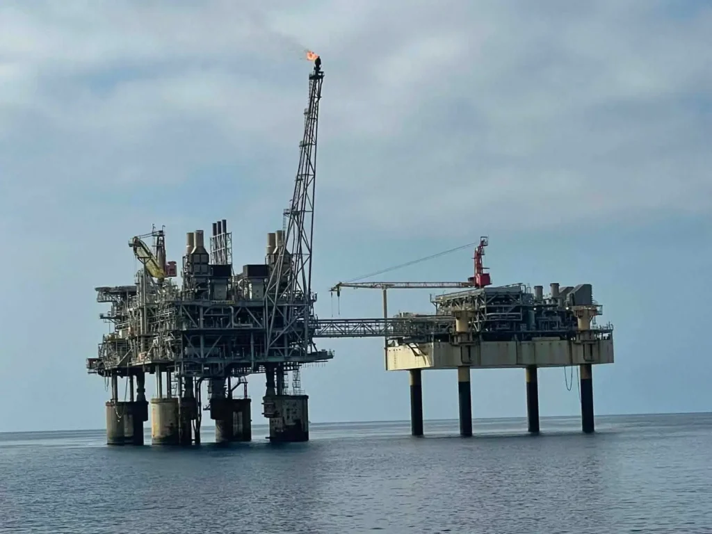
Energy dimension: the Malampaya East discovery
On 19 January, President Ferdinand Marcos Jr. announced a significant natural gas discovery at the Malampaya East 1 (MAE-1) reservoir, located about five kilometers east of the existing Malampaya field off Palawan — the country’s first major gas find in more than a decade. The reservoir is estimated to hold around 98 billion cubic feet of gas in place, with initial flow tested at 60 million cubic feet per day; the government projects it could power roughly 5.7 million households for a year. A second well, Camago-3, was announced on 26 March as part of the same Malampaya Phase 4 campaign, with first gas targeted for the fourth quarter of 2026
The discoveries carry strategic weight beyond energy security, which has become acute amid a national energy emergency declared in response to Middle East–driven fuel price shocks. Although Malampaya itself lies firmly within the Philippine EEZ, the broader field sits within, or near, the area enclosed by China’s illegal nine-dashed line — raising the prospect of future interference, coercion or attempts by Beijing to assert control over the surrounding waters as development accelerates.
Chinese research and survey vessels
Chinese research and survey vessels were monitored operating in Philippine waters throughout the period. The most frequent and persistent presence was Tan Suo Er Hao (Exploration No. 2), an 87.25-meter advanced deep-sea research vessel operated by the Chinese Academy of Sciences’ Institute of Deep-Sea Science and Engineering, with four documented instances between January and April. Independent monitoring group SeaLight, led by former U.S. defense attaché Ray Powell, tracked the vessel departing Sanya on 15 March and conducting what it characterized as unauthorized survey activity inside the Philippine EEZ from early April — first in the resource-rich Philippine (Benham) Rise east of the archipelago, then in the vicinity of Batanes.
During its latest documented passage in late April, Tan Suo Er Hao loitered approximately 93 nautical miles west of Burgos, Ilocos Norte — an area of strategic concern given its proximity to the Cahaya Malaysia subsea cable, a component of the Asia Submarine-Cable Express system linking the Philippines, Japan, Hong Kong, Singapore and Malaysia. The behavior may indicate surveillance, reconnaissance or positioning for future operations targeting this connectivity infrastructure.
Two other vessels — Shi Yan 1 and Yue Xia Yu Zhi 20033 — displayed prolonged low-speed transit and on-station patterns consistent with deliberate marine scientific research rather than routine passage. While Shi Yan 1‘s remote-sensing capabilities could in principle support monitoring related to Balikatan 2026, the overall operational profile of both vessels pointed to a research-oriented primary mission in late April. Both may possess intelligence-collection capabilities, but observed behavior aligned more closely with research.
By contrast, Hai Yang Shi You 760, Xiang Yang Hong 03, Shen Hai Yi Hao and Hai Yang Dizhi Liu Hao appeared to transit Philippine waters through the Luzon Strait en route to the Pacific. They maintained standard passage speeds with no prolonged loitering, suggesting Philippine waters served as a transit corridor rather than an operational area.
Undersea infrastructure: an emerging front
The recurring presence of survey vessels near the Cahaya Malaysia cable fits a wider pattern of concern. In early January 2026, the Philippine Navy confirmed it had begun developing means to monitor and protect submarine cables and other critical undersea infrastructure, citing cable-cutting incidents in the Taiwan Strait, Red Sea, and Baltic Sea, and the recovery of suspected Chinese underwater drones in Philippine waters in recent years. Numerous cables crossing the Philippine maritime domain connect Southeast Asia to the United States, India, Japan and Hong Kong, carrying data vital to trade and communications. The loitering behavior of Chinese research vessels in the vicinity of these lines — whether for mapping, tapping or positioning — is increasingly treated by Manila as a national-security matter rather than a purely scientific curiosity.
Legal assessment
The continued presence of Chinese vessels conducting activities in Philippine waters may constitute violations of both UNCLOS and the Philippine Maritime Zones Act. Both frameworks recognize the Philippines’ sovereign rights to explore, exploit, conserve and manage living and non-living natural resources within its EEZ and continental shelf, and both require a foreign state to obtain the coastal state’s consent before conducting marine scientific research in that EEZ. China’s enforcement measures at Scarborough Shoal — the floating barrier in particular — and its unauthorized survey activity remain inconsistent with the 2016 Arbitral Award and the 2002 Declaration on the Condut of Parties in the South China Sea. It must be noted that before the establishment of Chinese presence in the Shoal in 2012, Filipino fishermen were free to conduct their livelihood devoid of harassment.
Outlook
The quarter reinforced a now-familiar dynamic: China steadily tightens control of key features and probes Philippine resolve, while calibrating its conduct to the presence of allied forces; Manila responds with sustained law-enforcement, transparency policy, and deepening multilateral security ties as a counterweight. With the tenth anniversary of the arbitral award in July, an expanding Balikatan footprint, accelerating energy development off Palawan, and growing scrutiny of undersea infrastructure, the conditions for friction at Scarborough and across the West Philippine Sea are likely to persist into the next reporting period.
Prepared as a quarterly West Philippine Sea situation report. Primary maritime observations are drawn from Philippine Coast Guard monitoring; external developments are corroborated with open-source reporting from February–April 2026, including Reuters, the Philippine Star, the Philippine News Agency, U.S. Indo-Pacific Command and SeaLight.